

In the space of just a few days, flash floods have decimated human lives and property in Dharali in Uttarakhand, Kinnaur in Himachal Pradesh, and Kishtwar in Jammu & Kashmir.
On August 5, floods gushed down Kheer Gad (also known as Kheer Ganga), and barrelled into Dharali village in Uttarkashi district in Uttarakhand. In seconds, the Himalayan village, located at the confluence of Kheer Gad and Bhagirathi river, was covered in 40-60 feet of sediment and debris brought in by the flood waters.
Mobile-phone footage captured the horrifying scenes of people trying to escape the deluge but being washed away.
It has been 10 days, and no one is the wiser about why the Dharali disaster happened and what the death toll was.
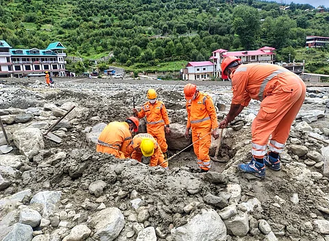
Even as rescue and relief operations are underway in Dharali, flash floods hit Rishi Dogri valley in Kinnaur district in the neighbouring state of Himachal Pradesh, on the night of August 13. Social media visuals show the river washing away roads, bridges and buildings. The Army is carrying out rescue operations.
The very next day, on August 14, over 500 kilometres away, in the remote village of Chishoti in Jammu and Kashmir’s (J&K) Kishtwar district, a cloudburst claimed several lives. It happened during the Machail Mata pilgrimage. Chishoti is the last point where pilgrims park their vehicles and go on foot to the Machail Mata temple, situated at an altitude of 2,800 metres.
What is a cloudburst?
While the term ‘cloudburst’ is being bandied about freely in media reports as the cause of these disasters in Uttarakhand, Himachal Pradesh, and J&K, it is important to note that all heavy rainfall is not a cloudburst.
‘Cloudburst’ is a term that should be used only after ascertaining the amount of rainfall a place has received.
According to the India Meteorological Department (IMD), 100 millimetre (mm) of rain in one hour is called a cloudburst. Usually, cloudbursts occur over a small geographical region of 20 to 30 square kilometres (sq km).
Simply put, 1 mm of rain is about 1 litre of rainwater for every square meter. Hence, if a cloudburst is 100 mm per hour, that is 100 litres for every square meter where it occurs. For a small geographical region of 20 sq km, that is about two billion litres of water in an hour. That is definitely a copious amount of rainwater for a small region to handle.
But, was it a cloudburst that drowned Dharali on August 5? The available precipitation data does not indicate that. There was moderate rainfall in the upper reaches of Dharali for the past couple of days, which may have triggered the disaster, as reported by Kavita Upadhyay in India Today.
There are possibilities of glacial lake outburst flood (GLOF) or landslide lake outburst flood (LLOF) leading to the Dharali disaster. But a final word on it will come only after proper assessment and field verification.
A Question of Answers
Blaming cloudbursts for high rainfall events and climate-induced disasters in the Himalayan region has become de rigeur. It begs the question, what are the government and local agencies doing to protect human lives; why are there no early warning systems or climate-resilient infrastructure; why have the repeated warnings of climate scientists about extreme rainfall events and their likely damages fallen on deaf ears?
Instead of blaming cloudbursts for the mayhem in the Himalayas, the media needs to find out why the intensity and frequency of these disasters are increasing, and what the government has done about it.
Have the successive governments done anything to build climate-resilient infrastructure in the hills? They are surely aware about so many hydropower projects in the Himalayan states being washed away by flash floods just in the past decade.
Where are the early warning systems that promised to save lives during extreme weather events? Why are more and more tourists-cum-pilgrims being allowed to throng the eco-fragile upper reaches of the Indian Himalayan Region where there is poor monitoring and insufficient data to build robust early warning systems?
In October 2023, the glacier-fed South Lhonak Lake in North Sikkim breached, causing a Glacial Lake Outburst Flood (GLOF) decimating the state’s largest hydropower plant. At least 35 people were killed and about 104 went missing.
This despite the fact that early warning sensors were installed in 2013, 2016 and even a month before the disaster at the critical glacial lakes in Sikkim. But those did not survive long enough to forewarn residents downstream, as reported in The Economic Times.
High Risk, Low Monitoring, Poor Data
The Himalayan region, crucial for its ecological and hydrological function, is highly sensitive to climate change, with significant impacts on the environment and human communities, notes a recent paper, Climate change in the Himalayan region: susceptible impacts on environment and human settlements.
Scientists and policymakers recognise the region as one of the world’s most vulnerable ecosystems, which is experiencing unprecedented changes in its cryosphere, hydrology and biodiversity. These changes will have a far reaching impact on the water resources, agriculture and livelihoods in the region.
Himalayan glaciers are retreating rapidly due to global warming and impacting millions of people across Afghanistan, India, Nepal and Pakistan, by threatening water supply to major rivers, such as the Ganges, Indus and Brahmaputra. The Gangotri Glacier has retreated over 1,500 m since 1935.
The Hindu Kush Himalayan range, spread across 3,500 kilometres in eight countries including India, could lose up to 75 per cent of its glaciers by the year 2100 if global temperatures rise by 2 degree C above pre-industrial levels.
Accelerated melting initially boosts runoff but leads to extreme water scarcity for millions far upstream once critical thresholds are crossed. This also expands glacial lakes, which heightens the risk of GLOFs.
As far as the Indian Himalayan Region (IHR) is concerned, which covers 12 hill states, it is a data-dark zone (see map). Climate scientists have cried themselves hoarse about the insufficient monitoring of weather and meteorological parameters in the upper reaches of the IHR.
For instance, the Geological Survey of India has recorded over 9,575 glaciers in the Himalayas yet detailed glaciological studies exist for less than 30.
“In India, we have good data sets on rainfall, temperature, humidity, wind speed, etc, which are the basic meteorological parameters. However, we don’t have adequate data over the Himalayas and hardly any data to work on GLOFs,” Madhavan Nair Rajeevan, one of India’s top climate scientists and former earth sciences secretary, pointed this out.
According to Irfan Rashid, Associate Professor, Department of Geoinformatics, University of Kashmir, the inventory of glacial lakes prepared by ISRO shows that there are 28,000 such lakes in the Indus, Ganges, and Brahamputra basins in the IHR.
But, ISRO is monitoring only those lakes which are greater than 25 hectares (ha). There have been GLOF events in smaller glacial lakes. For instance, in the union territory of Ladakh, there is a village of Gya which has an upstream pro-glacial lake of 9 hectares which experienced a GLOF in 2014. And it destroyed a few bridges and houses in the downstream village of Gya.
Since we have smaller glacial lakes which have also experienced GLOFs and have impacted downstream communities and infrastructure, there is a need to monitor them too.
Similarly, most monitoring in the upper reaches of the IHR is done through satellites. There is negligible in-situ data around glacial lakes. Remote sensing is a great tool to map glacial lakes. But, as far as GLOF risk is concerned, mapping is one small data set which can be incorporated into hazard assessment.
In the Indian Himalayan Region, we do not have bathymetry or the volume assessment of what is contained within these lakes, warns Rashid. He is working on a Ministry of Earth Sciences project profiling 15 glacial lakes in Jammu & Kashmir and Ladakh to improve data collection in the Himalayan cryosphere (the frozen part of the Earth system), which could help predict GLOFs.
There is no time to chill. Climate change is here and now. Acting on it and building climate resilience is the need of the hour.
Have you liked the news article?