

Year 2025 deserves to be called as the Year of Floods. Almost every state of the India experienced floods. Arid regions like Marathwada in Maharashtra also faced devastating floods like never before. Some of the worst floods were seen in the states at the foothills of Himalayas for multiple reasons like fragile geology, steep catchments, melting icecaps and mainly eroded flood carrying capacities of the rivers.
We can’t afford to ignore this alarm. It is high time; we redraw our development policies to minimise floods, its severity and impacts. It is unambiguously visible that one of the major causes responsible for the destruction caused by these floods is thoughtless anthropogenic interferences in the nature under the pretext of “infrastructure” or “development”.
On 25th and 28th August this year, Jammu city in North India experienced catastrophic floods of Tawi River. The destruction caused by the floods is unimaginable. Innumerable properties were inundated, tens of thousands of citizens were evacuated to safe locations and the damages are incalculable. After more than three weeks, basic infrastructure like water supply and electrical supply also was not in place at many locations.
Tawi originates at Kailash Kund Range and flows down through Jammu to meet Chenab in Pakistan. Total length of Tawi is 141 Kilometers (Kms) out of which 116 Kms are in India and remaining 25 Kms are in Pakistan. Jammu is situated at around 94 Kms from its origin.
More than these figures, the significant character of Tawi is its free catchment on the upstream of Jammu, which is entirely a hilly region with very steep gradient. But when Tawi enters Jammu City, its gradient is relatively flat. This topographical situation has significant impacts on the behaviour of Tawi. Due to the steep catchment on the upstream, the surface runoffs are fast and voluminous resulting in quick and steep rise in water surface levels. Whereas the velocity of the river reduces considerably when Tawi enters Jammu city due to relatively flat gradient. This situation makes the city far more vulnerable to floods in comparison to other cities.
TAWI RIVER FRONT DEVELOPMENT
Slower the velocity, river needs more space or width to carry its flow and this fundamental principle is completely disregarded while planning the Tawi River Front Development (RFD) at Jammu. Along 2.5 km of Tawi riverbanks, River Front Development project is almost complete.
The project involves construction of massive embankments right on the riverbed to reclaim the flood plains by filling debris along both the banks. This has resulted in 35 to 40 per cent reduction in the width/cross-section/flow area of the river. This obviously has led to proportionate rise in flood levels which subsequently caused huge inundation in Jammu City.
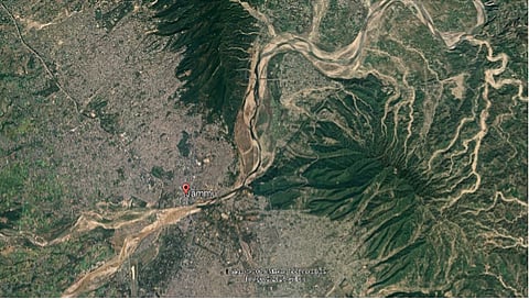
These Google Satellite images prove that the embankments constructed for the RFD project, have reduced width of Tawi from 450 Meters to 285 Meters in Jammu city. If these embankments which are encroaching upon the natural riverbed were not constructed, the maximum flood level of 34 feet on 26th August 2025 would have remained much low causing far lesser inundation and damages.
Given consideration to the changing rain pattern and frequent events of intense precipitation due to climate change, to save Jammu City from such floods in future, there is no option but to give the river its original space by removing all encroachments including Tawi RFD which is the largest encroachment and needs to be removed on the highest priority.
BARRAGES, A BIG BLOW TO THE RIVER
While leaving Jammu City, Tawi splits into two flows — Badi Tawi and Nikki Tawi — forming a riverine island of around 19-20 km in length. Immediately after this bifurcation, two huge barrages are built to store the river water. These barrages also have played a crucial role is aggravating the Jammu floods.
As mentioned earlier, on the upstream, Tawi flows through hilly region with much higher velocity causing erosion and carrying huge quantities of silt. The sill levels of the barrages are about 12 to 15 feet above the original riverbed level. Most of the silt gets deposited before the barrages up to the sill level raising the original level of the river bottom by 12 to 15 feet on the upstream of the barrages i.e. within the city.
Obviously, the flood levels also went up by 12 to 15 feet aggravating the flood situation making it far worse and disastrous. In absence of these barrages, the flood level would have remained much low in Jammu City and the inundation as well as the destruction would have been far less.
Climate change is a phenomenon which cannot be reversed in a short period of time. Occurrences of intense precipitation events are rising. The topography of the catchment of Tawi on the upstream of Jammu cannot be altered. Therefore, the only option in our hands is to “Let the River Flow Freely”, causing minimal inundation and destruction. We definitely can achieve it; if there is scientific approach with strong political will.
To save Jammu City, irrespective of the tall claims of the project consultants and project proponents, there is no option other than dismantling the barrages and the embankments constructed for the River Front Development project.
The need of the hour is to return to the rivers their original space and keep safe, respectable distance from them. If we do not do this, rivers are ruthlessly indomitable to reclaim their own space.
(Sarang Yadwadkar is an architect and works on the issues of river pollution and urban floods. He was a state government appointed member of the Planning Committee for Pune City’s Development Plan. He is also a recipient of “Bhagirath Prayas Samman” from India Rivers Forum, “Aniruddha Bhargava Environmental Award” from INTACH, and “Nisarg Sevak Puraskar” from Nisarg Sevak, Pune.)
Have you liked the news article?