

This news article is two-part series. Part-II is published today. Part-I and can be read here.
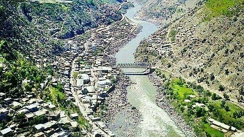
DODA: Doda's earthquake-zone label may be contested, but its exposure to disaster more broadly is not.
District disaster-management materials identify landslides, flash floods, cloudbursts, avalanches in the higher reaches, road accidents and fires alongside earthquakes as hazards requiring active preparedness. The district's response system rests on emergency coordination, a control room, mapping of vulnerable locations, evacuation and relief planning, coordination between civil administration, police, health services, public works agencies and response forces, and damage assessment for houses, roads, bridges, schools and public infrastructure.
On paper, this looks comprehensive and good. In practice, a disaster-management plan is only as useful as the data behind it. In keeping with the classification gaps already described in the first part of this report, much of that data is not yet public.
A current, credible assessment would need to disclose how many landslide-prone locations and vulnerable habitations have been identified, the condition of evacuation roads, the availability of shelters and emergency medical facilities, how many buildings have been assessed as unsafe, how many families have been displaced by landslides or subsidence, response times recorded during recent emergencies, and the availability of earth-moving equipment and trained rescue personnel.
The wider disaster-management architecture also requires states and districts to build risk reduction into development planning. This principle in Doda applies directly to decisions on mining leases, crusher locations, road widening, hydropower projects construction, settlement expansion and riverbed activity.
Thathri: A warning from the ground itself
The clearest recent illustration of ground risk in Doda did not come from an earthquake at all. In February 2023, ground subsidence in the Nayi Basti area of Thathri reportedly opened cracks in houses, roads and other structures, displacing several families and leading to some buildings being declared unsafe.
Land subsidence and earthquake activity are different geological processes, and the Thathri incident should not be described as an earthquake unless an official investigation formally establishes that link.
Available reporting based on versions of government officials and experts has attributed the subsidence to factors including water seepage, drainage problems, unstable geological formations and excessive loading.
How many structures were inspected and declared unsafe, which authority carried out the assessment, whether a geotechnical investigation was completed, and whether affected families received relocation support all remain undocumented in public view.
Thathri demonstrates that parts of Doda are vulnerable to ground instability. It does not, by itself, show that mining caused the subsidence, or that the rest of the district faces the same risk.
The mining question
Mining does not, on its own, cause earthquakes, and nothing in the official record reviewed for this report establishes that mining triggered any earthquake recorded in Doda. What uncontrolled excavation, riverbed extraction, road cutting, blasting, heavy machinery and altered drainage can do is add to a slope's vulnerability to erosion, rockfalls, landslides and infrastructure damage.
Whether that is happening in Doda has not been tested by any publicly available, site-specific scientific study and, as the first part of this report showed, even the baseline hazard map such a study would need to work from is not settled.
Whether mining adds to that vulnerability is a matter of location, depth, method and scale, not a blanket yes or no. Excavation on unstable slopes can strip away natural support; riverbed extraction can alter channel geometry and bank stability; poorly managed spoil disposal can obstruct drainage; heavy vehicles wear down roads and add pressure to slopes that may already be unstable; blasting carries its own risks depending on site geology, charge size and distance from structures. These remain risk hypotheses, not established findings, for Doda specifically.
Testing them would mean examining, lease by lease, the boundaries of each mining operation, the approved mining plan, permitted quantity against actual extraction, distance from settlements, roads and bridges, use of blasting or heavy machinery, riverbank and drainage changes, crusher permissions, environmental clearances and transportation records. All these need to be weighed against compliance with the Environment Protection Act, the Water Act, the Air Act and applicable mining rules.
Without that granular picture, enforcement reports can show that authorities detected alleged violations. They cannot, on their own, establish the environmental consequences that followed.
A regulatory framework with many layers
Mining and mineral transport in Jammu and Kashmir sit under a stack of Union Territory rules, environmental laws, pollution-control requirements and national monitoring systems: the Mines and Minerals (Development and Regulation) Act, 1957; the Environment (Protection) Act, 1986; the Water and Air Pollution Control Acts; environmental-impact-assessment requirements overseen by the Ministry of Environment, Forest and Climate Change; Jammu and Kashmir's own minor-mineral rules; consent orders from the Pollution Control Committee; district mineral plans; electronic transit permits and royalty records; and directions from the National Green Tribunal and higher courts.
The Ministry of Mines' national surveillance strategy layers digital monitoring and satellite observation on top of this, designed to flag unauthorised mining, transportation and mineral movement.
Jammu and Kashmir authorities have pointed to the use of such mechanisms, but have not made public how many alerts they generate, how many are verified, or how many lead to seizures and prosecutions. A regulatory system cannot be judged by the existence of a portal or a meeting. It can be judged only by outcomes.
What the enforcement numbers show and don't
Enforcement figures now in circulation hint at both the scale of activity and the gaps in verification. For the 2025–26 financial year, reported figures cite 9,417 seizures, 285 FIRs registered and more than Rs 20 crore recovered in penalties. These numbers require confirmation from official Mining Department records, and their precise geographic scope also needs clarifying, before they can be treated as settled fact.
What the "seizures" include remains less clear. . The following questions remain unanswered: Was the material weighed or estimated? What type of mineral or aggregate was seized? Were both machines separately identified? Was an FIR registered? Where was the material stored? What was the final legal outcome? Was the penalty paid or merely assessed? Was the material released, auctioned or returned? Was the site inspected for environmental damage?
For Doda specifically, the same period reportedly produced just one FIR and roughly Rs 28 lakh in penalties - figures that should not be treated as established without a district-wise statement from the Mining Department, police, or an official Right to Information response.
A low FIR count does not, on its own, prove that illegal mining is going unaddressed; it may reflect the line between administrative violations and criminal offences. But the gap between Doda's own figures and the larger totals reported alongside them is wide enough to justify asking whether enforcement data fully captures the scale of violations detected in the district.
Several specific 2026 enforcement actions add texture but await confirmation. One account describes a July 2026 operation in the Ghat area in which officials allegedly seized a JCB, a heavy excavator, a loaded tipper and close to 976 metric tonnes of raw and finished material. This is a claim that would require the official seizure memo, a district administration release or a police case record to confirm, along with basic details such as whether the material was weighed or estimated and whether an FIR was registered.
A separate report describes two vehicles seized in Bhaderwah with a combined penalty of Rs 52,064, and a third refers to two dumpers intercepted in Khellani allegedly carrying bajri without required documents, its date unclear. If confirmed, these cases point to continuing enforcement activity. On their own, they do not establish how widespread illegal mining is across the district.
In February 2026, the District Level Task Force Cell reportedly reviewed the regulation and monitoring of mining activity in Doda, including the Mining Surveillance and Monitoring Portal and the scrutiny of land-use-change documents submitted for crushers and hot-mix plants. That such a review took place signals that authorities recognise mining regulation cannot rest solely on stopping individual vehicles at checkpoints. A monitoring system only matters if its findings are recorded publicly and followed by timely enforcement.
Stone crushers, the Chenab, and the Green Tribunal
The most detailed scrutiny of mining activity near Doda has come not from a district office but from the National Green Tribunal, approached over allegations concerning stone crushers and mining near the Chenab. The original complaint alleged that 10 to 12 stone crushers were operating within roughly five to six kilometres of Doda town - an allegation, not the confirmed result of an official survey.
A later compliance report reportedly found no mining lease within the polygon-marked site under examination, identified three stone-crusher units, and stated that their material was sourced through lawful channels or valid disposal permissions. If confirmed, that finding would apply only to the specific site examined, not to all mining or crushing activity across the wider Doda area.
A lawful source of raw material does not by itself prove a crusher meets its full environmental and pollution-control obligations, which extend to siting and operating conditions, dust, noise and water-pollution controls, and the rehabilitation of exhausted quarry sites. Establishing the fuller picture would mean examining the tribunal's original application, affidavits, Pollution Control Committee reports, site-inspection findings, and the tribunal's orders on restoration, closure or further inspection.
Two unknowns compounding each other
No single quarry, crusher or vehicle seizure tells the full story on its own, and no single hazard label - Zone IV, V or VI - tells the full story either. The more consequential question is how these two uncertainties compound one another.
Earthquake shaking, heavy rainfall, natural rock fractures, road cutting, excavation, altered drainage and construction loading can all interact on a fragile mountain slope. The presence of several risk factors at one place does not automatically prove that any one of them caused a specific event, but their combined effect can make landslide and infrastructure risk considerably harder to manage and harder still to manage well when the underlying hazard classification itself keeps shifting.
A fuller investigation would need both threads addressed together: satellite and GIS analysis tracking changes in quarry footprints, river channels and landslide scars over several years, drawing on geological and geomorphological mapping from the Geological Survey of India and river-channel data from the Central Water Commission, with methodology and imagery dates published for independent review; a lease-by-lease check of every active quarry and crusher against approved plans and clearances; hydrological studies comparing pre- and post-monsoon river conditions; geotechnical assessment of slopes where excavation or drainage changes may be raising landslide risk; and an authoritative, current, publicly accessible statement of which seismic zone actually applies to which part of the district. The latter needs to be updated as national and state codes change, rather than left to circulate in inconsistent secondary accounts.
What the evidence currently shows
Doda is exposed to significant seismic and slope hazards - that much is undisputed, even if officials themselves cannot settle on which zone number to attach to it. The district has experienced notable earthquake activity and a serious ground-instability incident at Thathri. Reported mining and quarrying enforcement actions, and the National Green Tribunal's continuing scrutiny of stone crushers near the Chenab, point to real regulatory concern, even where individual figures still need official confirmation.
What the available material does not do is establish that mining caused Doda's earthquakes, the Thathri subsidence, or any specific landslide. Nor does a handful of enforcement cases establish how widespread illegal mining is across the district. What it supports is the case for two things: a formal, site-specific investigation into mining's cumulative effect on slope stability, and a single, authoritative, continuously updated public statement of Doda's seismic classification.
This report draws on the following sources:
National Centre for Seismology, Government of India, earthquake catalogue and event records: https://riseq.seismo.gov.in/
National Disaster Management Authority, Government of India, earthquake and disaster-risk-reduction guidelines: https://ndma.gov.in/
District Administration Doda, disaster-management information and district records: https://doda.nic.in/
Government of India, Ministry of Mines, mining laws, regulations and monitoring systems: https://mines.gov.in/
Jammu and Kashmir Mining Department, official notifications, enforcement records and mineral-transport information: https://jkmine.jk.gov.in/
Jammu and Kashmir Pollution Control Committee, consent orders, inspection reports and compliance records: https://jkpcc.nic.in/
National Green Tribunal, original applications, orders and compliance proceedings: https://greentribunal.gov.in/
Ministry of Environment, Forest and Climate Change, environmental-clearance framework and notifications: https://moef.gov.in/
India Code, Mines and Minerals (Development and Regulation) Act, 1957, and related legislation: https://www.indiacode.nic.in/
Geological Survey of India, landslide, geological and hazard-mapping resources: https://www.gsi.gov.in/
Central Water Commission, river, flood and hydrological information: https://cwc.gov.in/
Jammu and Kashmir government and district administration press releases, seizure memos, penalty orders, task-force minutes and disaster-management records, to be obtained and independently verified before publication.
Relevant peer-reviewed scientific studies on Himalayan seismicity, landslides, river morphology, quarrying and cumulative mountain hazards.
Relevant news reports hyper-linked in the text.
Right to Information responses and certified government records concerning Doda’s mining leases, crushers, seizures, FIRs, penalties, environmental clearances, disaster assessments and rehabilitation measures.
Have you liked the news article?
Support us now:
https://www.gofundme.com/manage/jammu-kashmirs-sole-independent-voice-under-threat